Explore Chiricahua National Monument, Arizona
See rhyolite rock spires and soaring hoodoos.

With Chiricahua National Monument in Willcox, Arizona, celebrating its 100th anniversary this year, now may be the best time to explore what’s often called a Wonderland of Rocks. Not because of the centennial, but because it may be our next national park, thanks to federal legislation that’s been introduced to redesignate this public land from national monument to national park.
This legislation is still working its way through Congress, but Tiffany Powers, chief of Interpretation Services, says that the bill has already “created a lot of buzz,” as have special centennial activities such as geology and living history programs. If Chiricahua does indeed become Arizona’s fourth national park, visitation numbers are expected to skyrocket as eager parkgoers turn up to get coveted stamps in their National Parks Passports for the newest one of all.
Set in the Chiricahua Mountains of southeast Arizona, the monument is best known for its geological features, including rhyolite rock spires and soaring hoodoos, created by a volcanic eruption 27 million years ago.
As you enter the park, make the visitor center your first stop for the scoop on the day’s park programs: ranger-led hikes, wilderness talks, and guided bird walks, to name a few, could be on the bill. A new Centennial Junior Ranger activity booklet lets children earn a special patch upon completion. From the visitor center, parkgoers can pick up the Lower Rhyolite Canyon Trail, which connects with several others, including the Sarah Deming Trail and Upper Rhyolite Canyon Trail.
But to get your first taste of the towering spires and natural geologic features that make up Chiricahua National Monument, hop in your car and slowly motor along eight-mile Bonita Canyon Drive. Stop at pullouts to ogle unusual rock formations with names such as Sea Captain and Organ Pipe. Continue all the way to the top to hike the 0.5-mile Massai Point Nature Trail for mountain vistas, valley views, and placards that educate visitors on canyon forests, balanced rocks, and the unusual landscape. From Massai Point, “you can see as far as 100 miles in every direction,” says Powers.
More than 17 miles of hiking trails allow visitors to immerse themselves in rock formations and moonlike landscapes. There are hikes for all levels, from the easy 0.5-mile Bonita Creek Trail, which winds along (often dry) Bonita Creek, to the strenuous 9.5-mile Big Loop, which cobbles together several scenic trails and viewpoints, including Echo Canyon, Big Balanced Rock, and Inspiration Point. As if physical activity, solitude, and fresh air aren’t enough, hikers who trek at least five miles at Chiricahua National Monument can earn an I HIKE FOR HEALTH pin.
Chiricahua National Monument is one of several “sky islands” in Arizona. These isolated mountain ranges curiously seem to sprout up from the desert floor, and thanks to a wide range of elevation and altitude, they boast an impressive diversity of native plant and animal species, ecosystems, and habitats including grasslands, desert scrub, riparian woodlands, and pine forests.
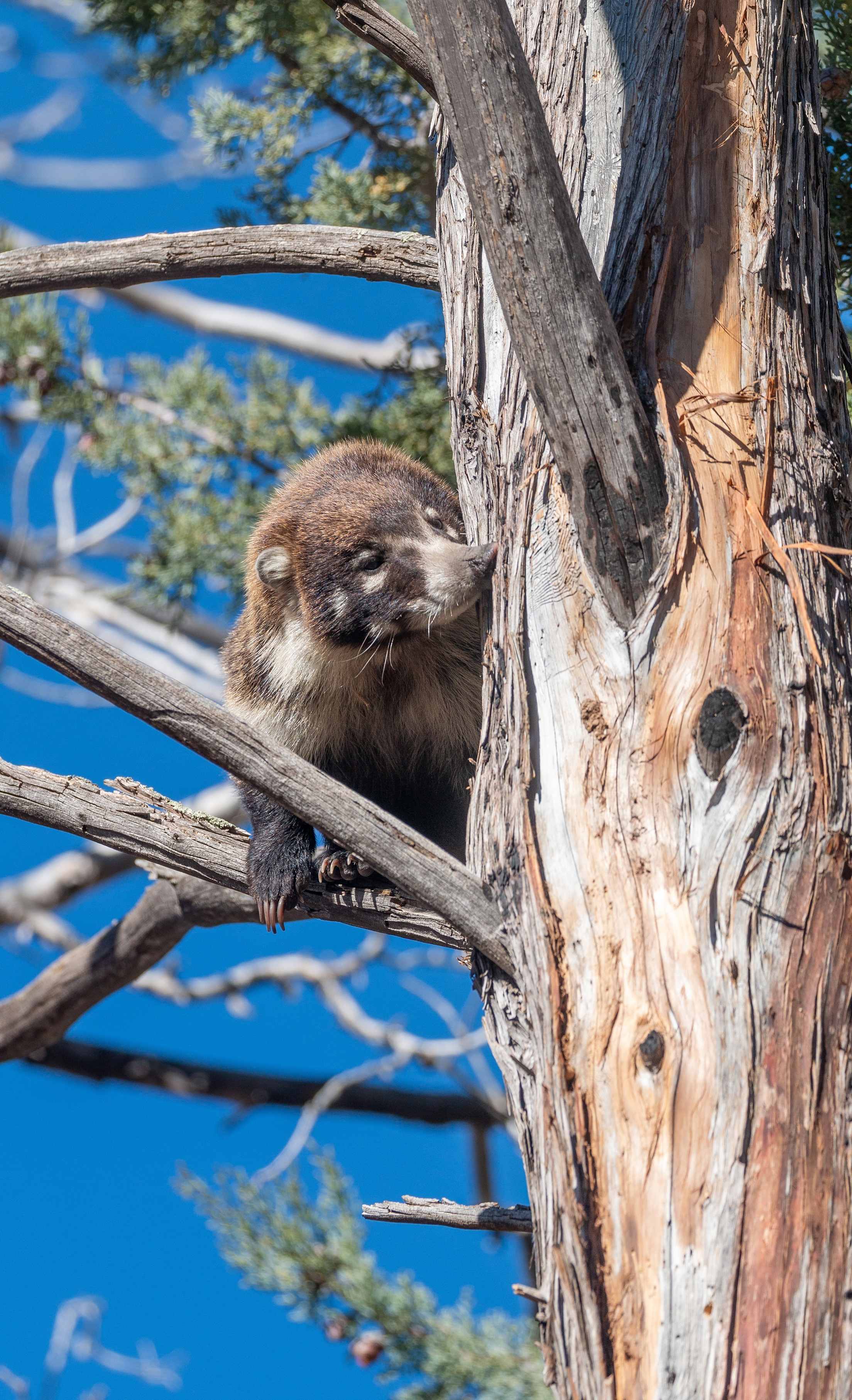
Keep your eyes open for wildlife, from western box turtles and cactus wrens to turkey vultures and tiger salamanders. The white-nosed coati, also known as a Mexican raccoon, is rare in the United States, but can be seen at Chiricahua, often in the early morning and late afternoon. A bumper crop of babies last year nearly doubled the park’s population to around 50 to 60 white-nosed coatis, according to Powers.
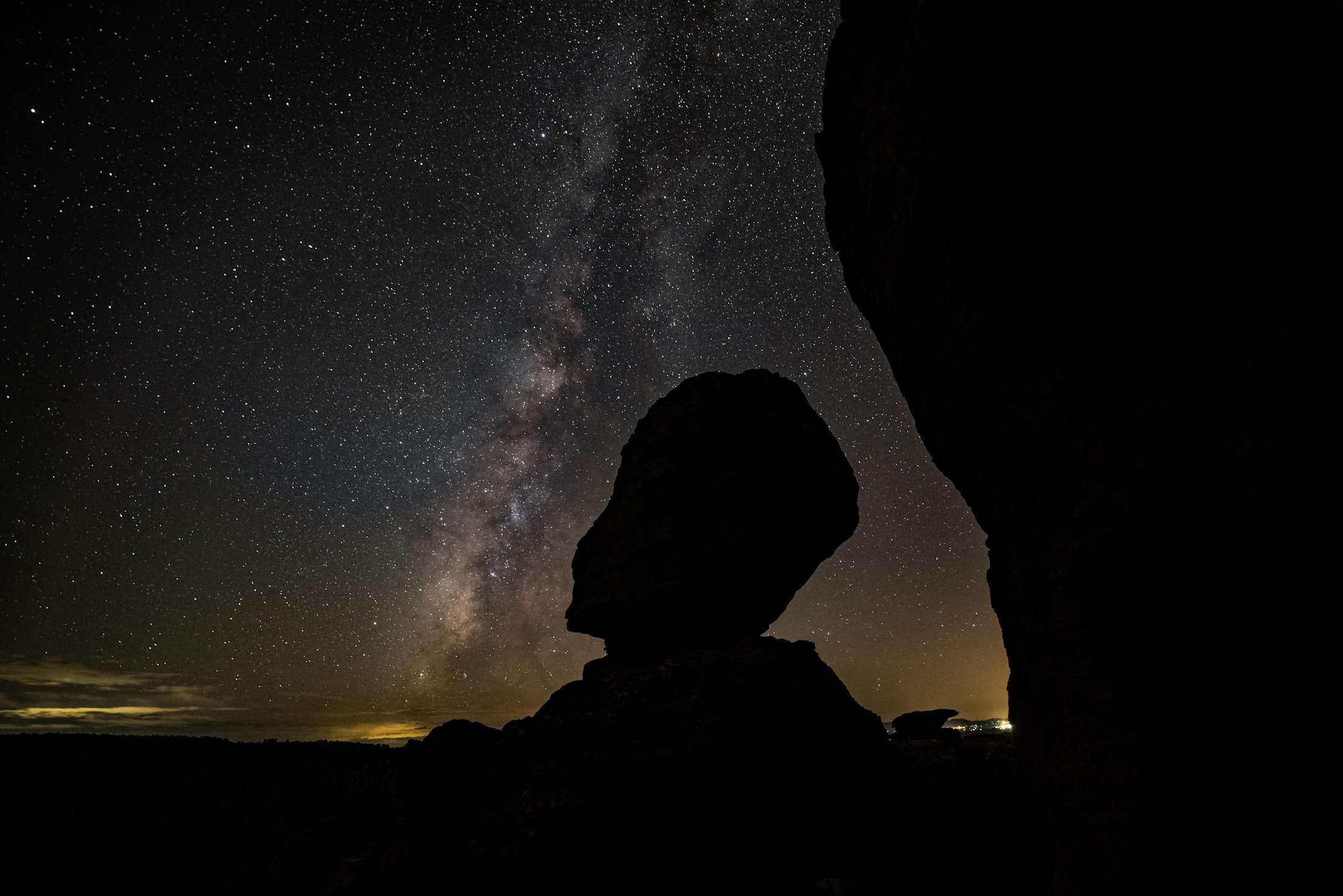
Stargazing is impressive at Chiricahua National Monument, which earned International Dark Sky Park designation in April 2021. In April and October, the park hosts dark-sky parties, setting up telescopes and inviting local astronomers from the Tucson Amateur Astronomy Association to help visitors see the stars and wrangle with a few of the infinite mysteries of our massive universe.
Bring a picnic lunch when you visit. There are several picnic areas, but more importantly, the park is quite remote. There is no on-site restaurant, and the closest stop for a meal is miles away (though light snacks are for sale in the visitor center). The small town of Willcox is a good bet to grab a bite, since it’s on the route to and from Tucson. It’s about 45 minutes from the visitor center and has several restaurants, including Big Tex Bar-B-Que and La Unica Restaurant & Tortilleria, as well as a Dairy Queen.
As you drive out, pull off Bonita Canyon Drive for Faraway Ranch, a one-time guest ranch and family homestead that sits in the shadow of this Wonderland of Rocks. The ranch, now a part of Chiricahua National Monument, is closed for renovations at least through 2025, but guided walks of the grounds are typically offered from September to May.
Chiricahua is best in the fall and spring, when the temperatures are more manageable. “Our busiest season is always going to be February, March, and April,” says Powers, noting the spring migration of such birds as the orange-crowned warbler and gray flycatcher. You’re wise to bring extra layers. In winter, you may get a snowfall, even so close to Tucson.”