Four Corners Road Trip
From ancient ruins to legendary red-rock terrain, this scenic loop is the essence of the desert Southwest.

Staking out our campsite on the edge of a 1,200-foot desert mesa, my wife, Leah, and I approached the edge. Below us, splayed out to the horizon, was a kind of geological mayhem: natural stone pyramids and silhouetted buttes, gash-like ravines and convoluted stream beds—the kind of scenery dreamed up by location scouts for classic westerns. But to our surprise, the real power of the place lay at our feet. I glanced over the edge of the first terraced cliff band and saw something totally unexpected. Just below us, on the side of the nearby rock buttress, was a striking panel of ancient petroglyphs, baking in the late afternoon sun.
That’s the beauty of travel in the Four Corners region, that dreamlike landscape where the corners of Arizona, Utah, Colorado, and New Mexico all converge. It’s not just one of the most photogenic road trips on earth. In this remote high-desert region, spectacular geology, star-drenched night skies, ancient indigenous ruins, and modern Native culture intersect in a way found nowhere else in the country. And every turn of the highway feels like a discovery.
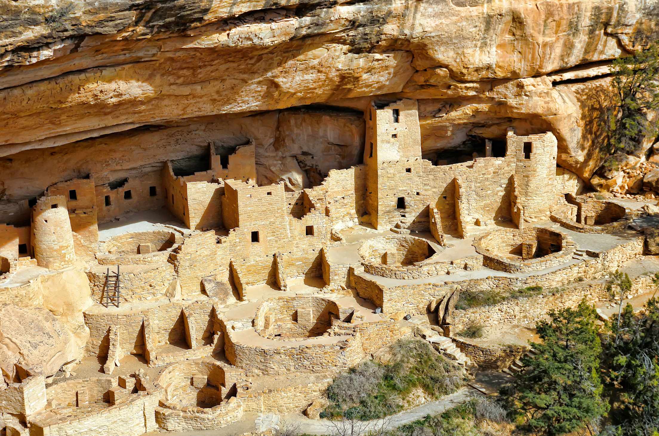
Mesa Verde National Park, Colorado
In southwest Colorado and southeast Utah, the route to stick to is the Trail of the Ancients Scenic Byway, which starts, more or less, in Cortez, Colorado. This is where the Rocky Mountains around Durango give way to the wide, arid expanses of the desert. It’s also your chance to fill up in one of the town’s three local craft breweries (Main Street Brewery & Restaurant is a mainstay) or any of several locally provisioned restaurants, such as the farm-to-table Farm Bistro. After this point in the trip, the desert dining will get a bit spartan.
Mesa Verde National Park draws most of the tourists into this corner of Colorado, and for good reason. It’s the crown jewel of ancient Indigenous peoples’ cliff dwellings, and a must-see on any Four Corners itinerary. Staying at the park’s lone hotel, the Far View, makes it easy to start the day with a ranger-led tour of the spectacular Cliff Palace, the largest cliff dwelling in North America, or the Balcony House, accessed by a series of vertigo-inducing ladders on a high cliff face.
Bears Ears National Monument / Cedar Mesa, Utah
The Trail of the Ancients turns sharply west at Pleasant View, swapping the state highway for county roads that meander past tiny Hovenweep National Monument, just across the border in Utah. The monument’s short trails lead you through six prehistoric village sites, replete with remnants of stone towers that boast an advanced, ancient masonry style rivaling Mesa Verde’s. But the real treasure of this area is the Comb Ridge and Cedar Mesa area, at the heart of Bears Ears National Monument. The controversial monument’s boundaries seem to change with shifts in the political winds, but the constant is a wonderland of ancient cave dwellings, granaries, and delicate petroglyphs, tucked away in the many sandstone canyons that branch off of Cedar Mesa. Unlike Utah’s other tourist-choked and heavily regulated national monuments, here countless private ruins invite you to sit in solitude, among the scattered corn husks and pottery shards left by the last of the Anasazi around 1,300 a.d., and wonder at the way of life of the Ancestral Puebloan people who still live in the region and have ties to landscape. The rangers at the Kane Gulch Ranger Station are happy to help pick a good half-day hike for the family, but the most immersive way to experience the canyons is to hire a local guide service, such as Ancient Wayves, for a bespoke trip to both public and private sites with a Native guide.
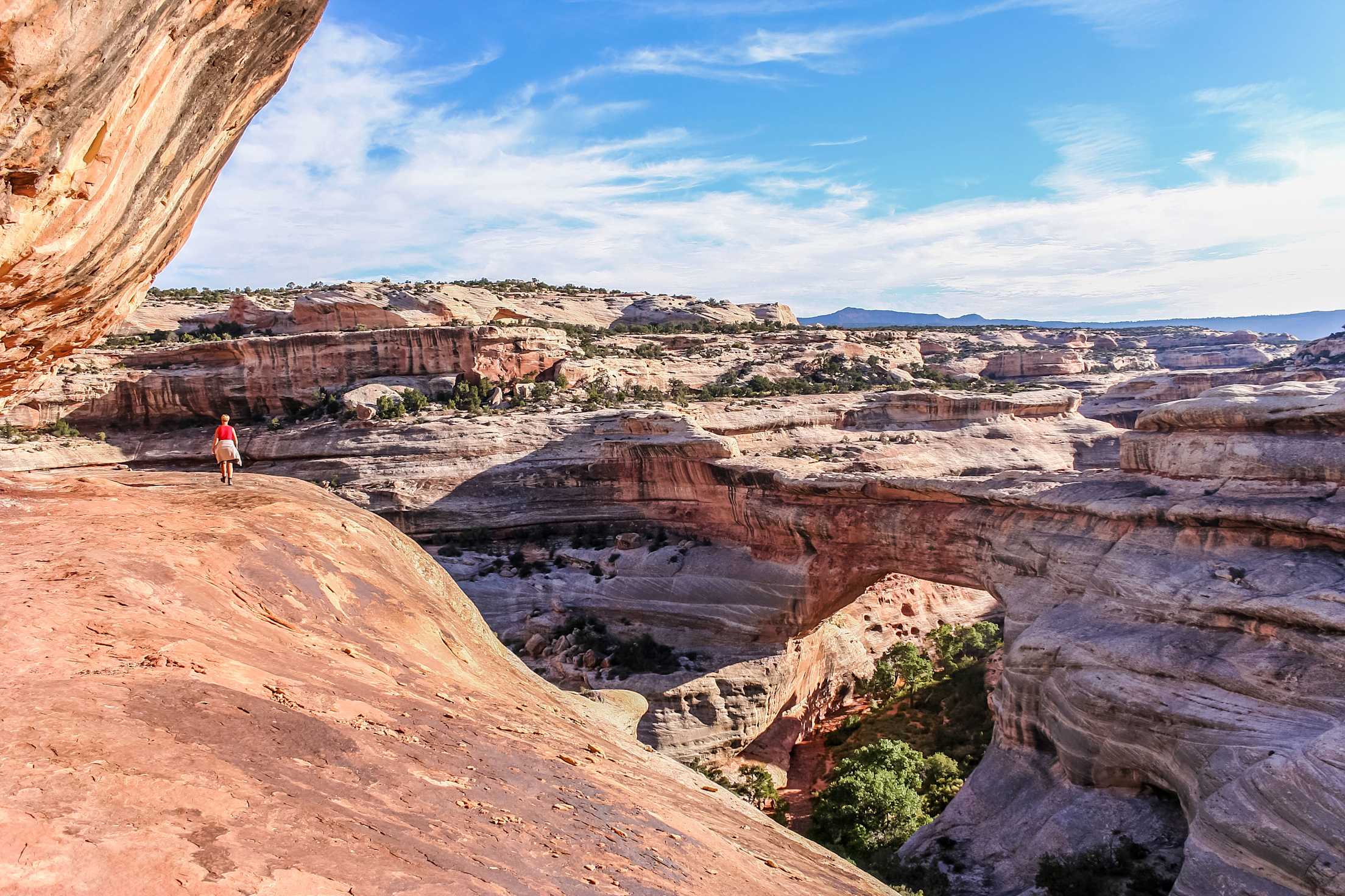
Natural Bridges National Monument to the Moki Dugway, Utah
Surrounded by Bears Ears National Monument are the three long, slender sandstone arches that comprise Natural Bridges National Monument. It’s easy to tour the overlooks in a couple of hours in relative privacy, or drop into the canyon system to see the arches up close on foot.
Natural Bridges became the world’s first designated International Dark Sky Park in 2007, but if you can’t stay for dark, don’t miss the sunset from nearby Muley Point, perched on a cliff overlooking the San Juan River Canyon on Cedar Mesa’s southern edge (and rumored to be Edward Abbey’s favorite vista).
Buckle up after this point, though. Ahead is the Moki Dugway—an engineering marvel of serpentine road work that switchbacks its way 1,200 feet down several sheer cliff bands. Originally built for uranium trucks during the Cold War, the Dugway descends at up to a 10 percent grade, often without guardrails, above several bracingly sheer drops. Despite the road’s white-knuckle reputation, it’s actually an easy drive for passenger cars, though the rusting carcasses of several old vehicles are testament to the need to keep both hands on the wheel. You’ll want to go slowly anyway, to enjoy the spectacular scenery unfolding around each turn.
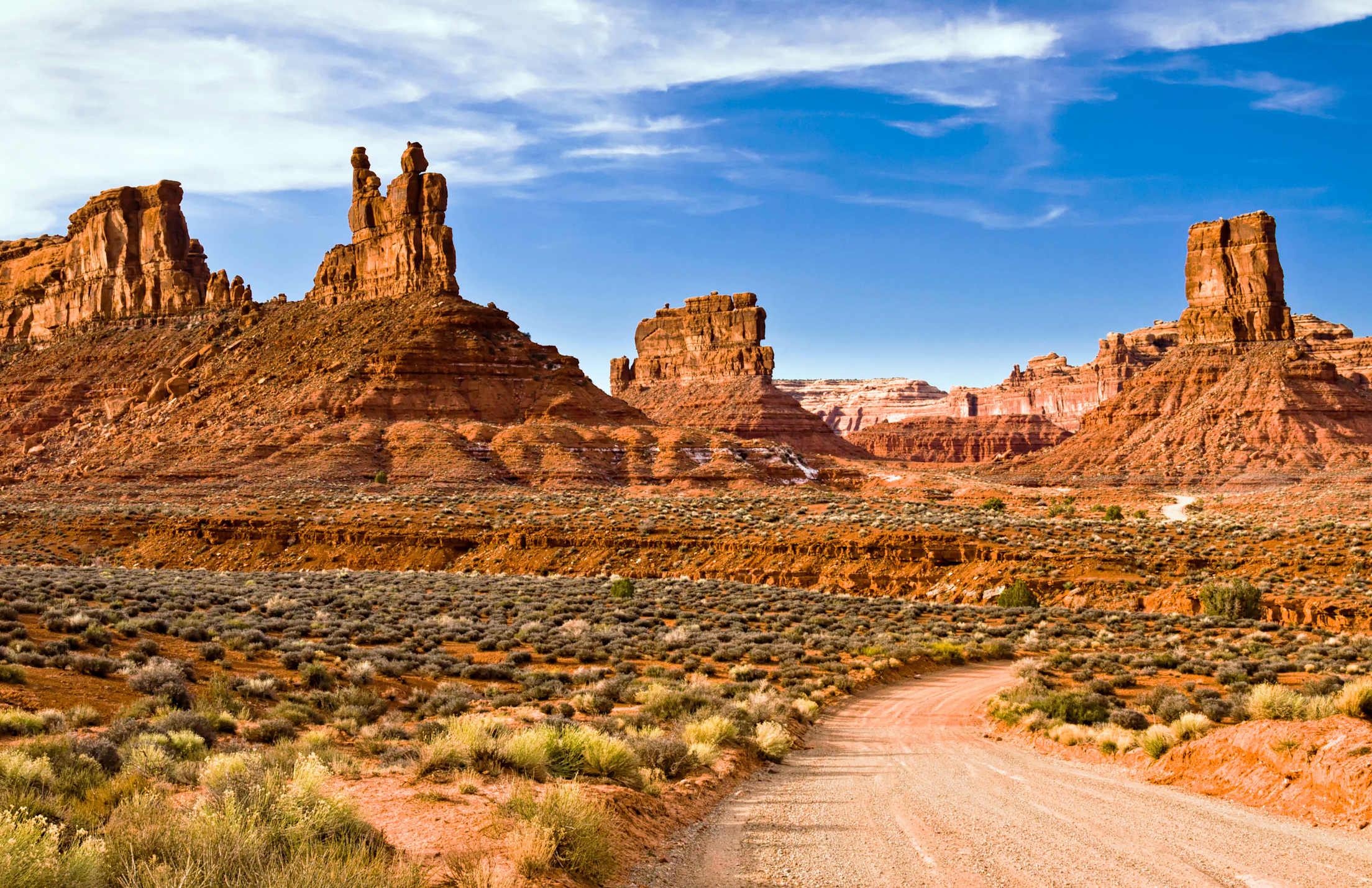
Valley of the Gods, Utah
For travelers with a moderately high-clearance vehicle, the Valley of the Gods road at the base of the Dugway is one of the more memorable drives in the country: a red-rock garden of elegant buttes, towers, and bus-size rocks teetering on spires—all with nearly no other travelers in sight. Winding along the washboarded, 17-mile gravel road takes about an hour and a half in dry weather, but is well worth the detour. It’s not hard to appreciate why the local Navajo view this place as sacred. Mind the forecast, though. A downpour can quickly render this road an impassable ribbon of clay slime.
For lodging, the historic Valley of the Gods Bed & Breakfast is winding down its long run as the area’s most refined lodging option (and, in the future, becoming a heritage center), but if you catch owner Claire Dorgan in a willing mood, you can still book the private stone house (an old root cellar turned guesthouse) and enjoy a glass of wine on its porch overlooking the valley.
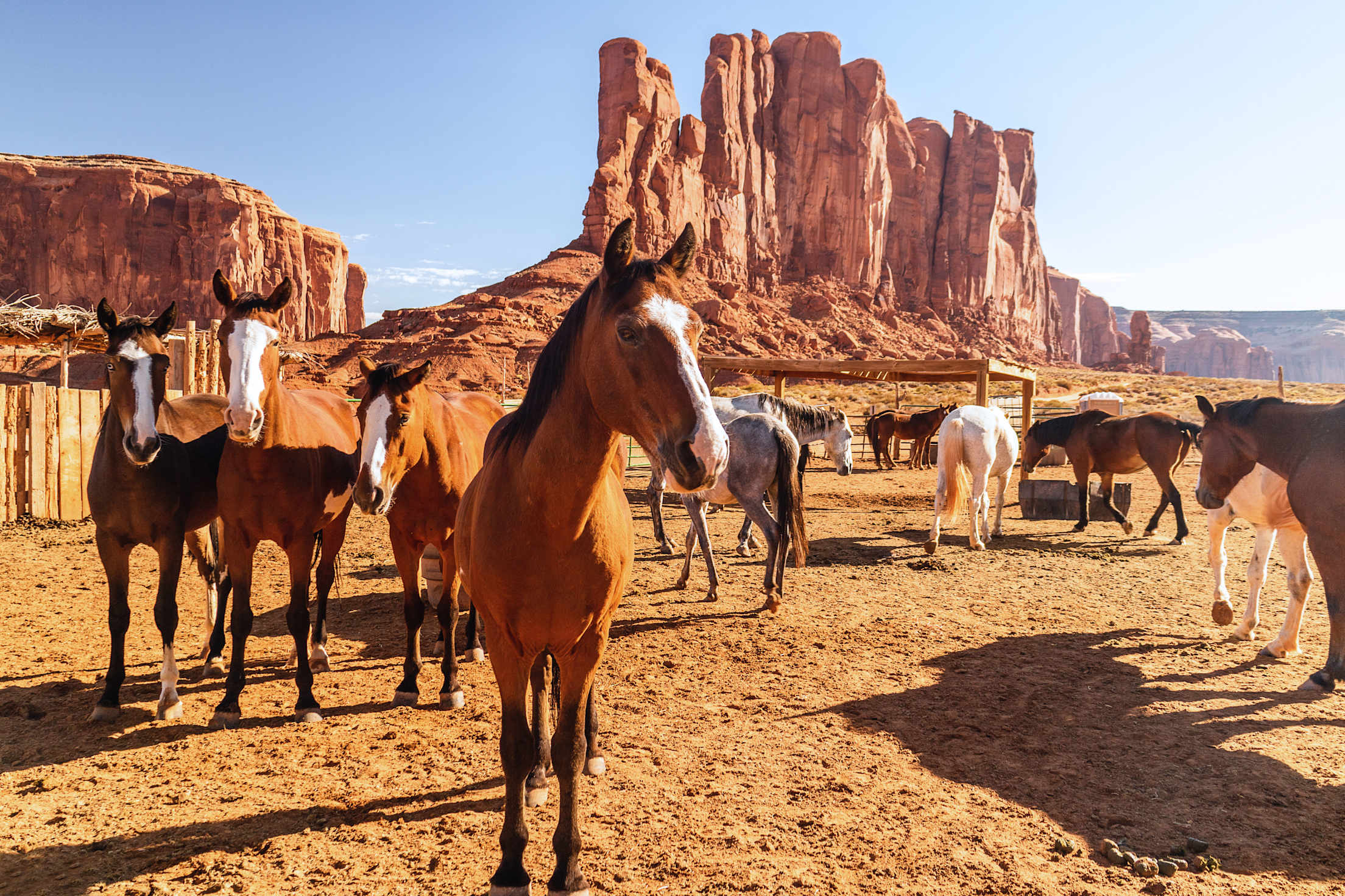
Monument Valley, Arizona
The Trail of the Ancients passes through the aptly named town of Mexican Hat (christened after a sombrero-shaped rock balancing precariously outside of town) before dropping into the red-rock outskirts of the Navajo Nation. The first real sight of Monument Valley happens at a much-Instagrammed spot known informally as Forrest Gump Point. It’s the spot where Highway 163 stops meandering and suddenly runs straight at the distant bluffs and spires of the valley, and where, in the 1994 classic film, the bearded Gump abruptly stops his 15,000 mile run. Slow down here to avoid hitting influencers posing in the middle of the highway.
Arriving in Monument Valley comes with a sense of déjà vu. This landscape of isolated, 1,000-foot buttes is instantly familiar, etched into the country’s collective consciousness through John Ford westerns, Marlboro ads, and infinite SUV commercials. All that’s missing is a guy on horseback and a sun-bleached bull skull to complete the panoramic set.
The experience of the Valley grows richer when you turn off the highway at the Utah–Arizona border, heading into the tribal park and onto the self-guided dirt road that loops through its famous red-rock features, such as the Mittens and Three Sisters. Stop by Linda’s Frybread Stand, near John Ford Point, with its unusually tasty fry-bread tacos, Mexican tacos, and other varieties of American gut bombs. Book a day on horseback, walk the self-guided Wildcat Trail, and spend some time with the galaxy here. The 95-room, Navajo-owned View Hotel features star-view balcony rooms where, on clear, moonless nights, the Milky Way arcs brilliantly above the silhouetted buttes. To traditional Navajo, this Yikáísdáhá—the spirit path of the ancestors—is the real trail of the ancients, each star being a footprint of those gone before.
Smart Tip: One thing you will get to know well in the Navajo Nation is fry bread. Thick, doughy, greasy, and irresistible, this ubiquitous staple forms the base of most local fare. Folded and smothered with savory spiced beef, beans, and fixings, it becomes a Navajo Taco. Doubled with a hamburger patty, it becomes a Navajo Burger. Drizzled with sugar and honey, it becomes a sweet dessert bread, like a Spanish sopapilla. Legend has it that fry bread was first made by the Navajo out of the meager rations (flour, lard, salt, and sugar) that they were given by the U.S. Army during their forced relocation to Bosque Redondo, New Mexico, during a brutal period of ethnic cleansing that the Navajo remember, with characteristic understatement, as the Long Walk. Today, you will see fry bread sold everywhere from hotels to ramshackle roadside shanties, where you’ll often find the best flavors and friendliest hosts.
Painted Desert Murals, Arizona
Gassing up in Kayenta, Arizona, you might notice the images on the wall of JoD’s Laundry, near the intersection of Highway 89 and Highway 163. It’s a 2014 mural by the artist Hyuro called “In Beauty It Is Finished,” depicting the stages of a Navajo morning prayer, a ceremony performed by some Navajo to greet the rising sun. Murals like these have recently been popping up on abandoned buildings, makeshift roadside vending stands, defunct gas stations, and water tanks on the Navajo Nation along 89 and 160, part of a street art movement kicked off by local physician and artist Chip Thomas. In 2009, Thomas started “recycling walls,” in his words, by pasting enormous, striking black-and-white photos of Navajo life and culture on the sides of abandoned buildings. In 2012, Thomas began recruiting world-famous artists including Alexis Diaz and up-and-coming Navajo muralists such as Daniel Josley to join him, and the Navajo Nation street art trend took off. Dozens of murals now enliven the landscape along the highways, some demanding unexpected stops along the roadside and some tucked just off the beaten path to discover by chance.
Canyon de Chelly, Arizona
From Kayenta, Highway 160 leads past striking, fantastical rock cones—the leftover cores of ancient volcanics—that lend an otherworldly aspect to the landscape on the way to Mexican Water. This is where Highway 191 (Tse’nikani-Flat Mesa Rock Scenic Road) drops down into a barren and spectacular stretch of red-rock gardens along the Chinle Valley and the entrance to Canyon de Chelly.
The softer counterpart to the Grand Canyon, Canyon de Chelly is a curvesome and elegant bastion of steep, red sandstone walls pocked with innumerable cliff dwellings, ruins, and petroglyph sites. Its fertile valley floor has been home to the Navajo for centuries, and to ancestral peoples for at least a thousand years before them. Peering down from one of the many viewpoints along the rims gives a sense of the sheer scale of this vast canyon complex. The park’s sole self-access trail (White House Trail) is closed indefinitely, so getting closer than the edge of the rim requires consulting the nearby hotels to book a local guide (such as the Teller family, who run Antelope House Tours and hail from a long line of Canyon de Chelly residents). You’ll spend the day four-wheeling to hidden petroglyph sites in the shade of hundred-year-old cottonwoods and pondering ruins at the base of the 800-foot walls.
A guide will be helpful for more than just avoiding the truck-swallowing quicksand at the mouth of the canyon. More than any other site in this part of the Southwest, Canyon de Chelly is a canyon of stories. There are petroglyphs so old they depict men using atlatls, a kind of handheld spear-thrower that was the hunter’s tool of choice before the bow and arrow. There are pictographs of Spanish conquistadors riding on horseback, their capes emblazoned with crosses. There is graffiti scratched by Civil War–era soldiers, and “planetarium caves” decorated with ancient star charts. Oral tradition, archaeology, history, and myth blend together around every bend of the canyon, with the oldest stories etched in mesmerizingly enigmatic figures on the walls themselves. A full day with a good guide can start to untangle the canyon’s mysteries, though—to borrow a petroglyph pun—it will only scratch the surface.
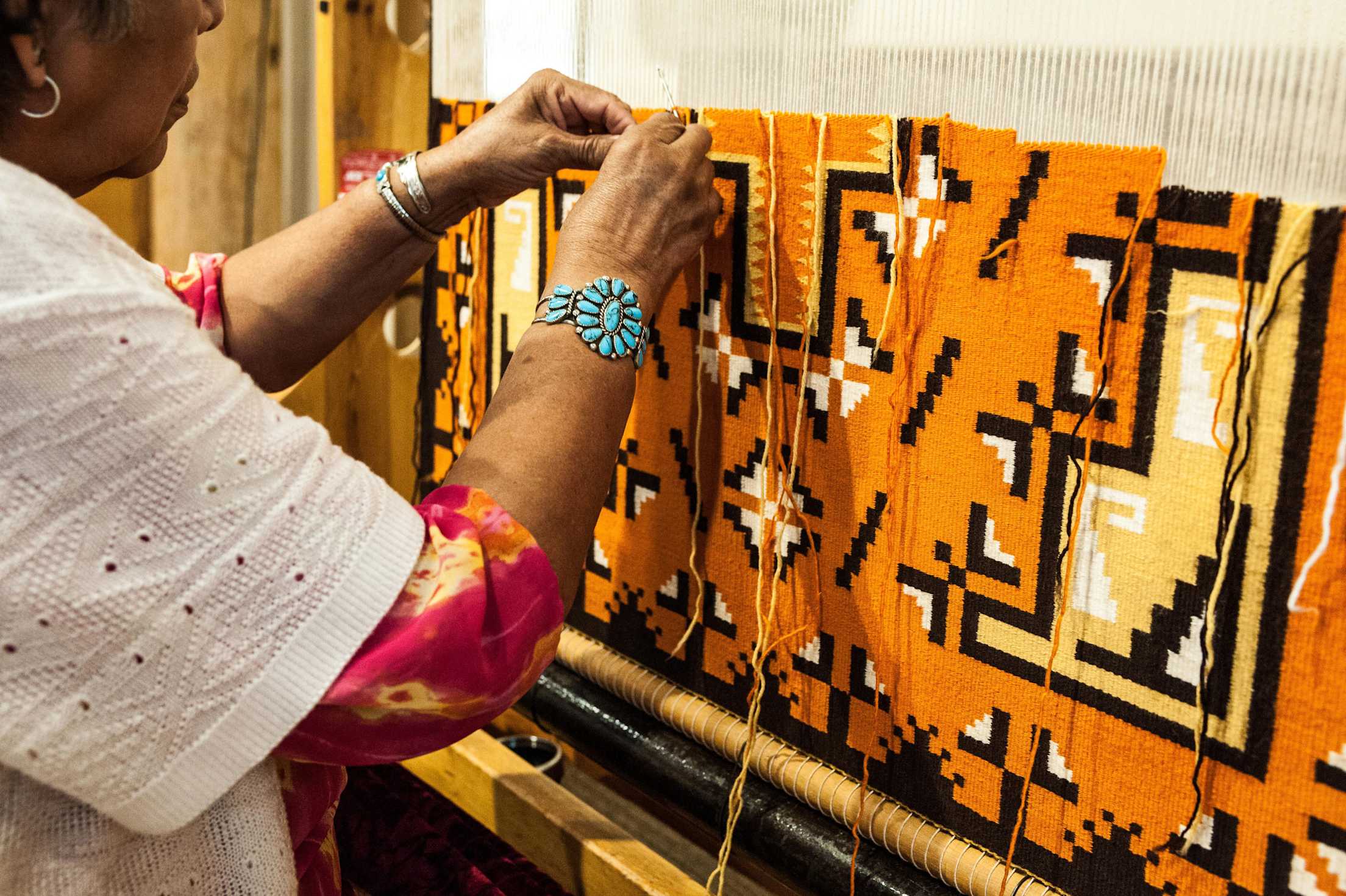
Smart Tip: Trading posts were the lifeblood of commerce in this part of the country going back to the end of the Civil War. The oldest continuously operating one is the Hubbell Trading Post (est. 1878) in tiny Ganado, Arizona, south of Canyon de Chelly—well worth a visit on the way to Gallup. Indian baskets hang upside down from ancient kiva roof beams amid blank-eyed taxidermy, antique saddles, piles of Navajo rugs, and assorted Western miscellany.
Navajo rug aficionados will want to spend hours going through the piles of authentic, locally woven options at the out-of-the-way Toadlena Trading Post and Weaving Museum, in Newcomb, New Mexico. It’s best reached by the scenic road along the north rim of Canyon de Chelly. In 1997, Santa Fean Mark Winter turned this hundred-year-old trading post into the centerpiece of the local weaving community, rejuvenating the Toadlena and Two Grey Hills weaving community in the process. Today, stacks of handwoven rugs made by local and master weavers are piled high on the floors—a serious collector’s bonanza—only a few miles from where they were made.
Chaco Canyon, New Mexico
If you took a road trip in the Four Corners region a thousand years ago, the road would have inevitably led you to Chaco Canyon. That’s because this ancient site was so important, it had its own extensive road system. This World Heritage Site in the sunbaked New Mexican Badlands was, at its zenith, the epicenter of Chacoan Anasazi society and culture, the largest and most sophisticated indigenous complex north of Mexico. What remains are the ruins of massive, multistory great houses such as the centerpiece Pueblo Bonito, which had between 600 and 800 rooms, and an underground kiva measuring almost 70 feet across. Chaco’s enormous structures were carefully planned in advance, oriented to cardinal and lunar directions, and exquisitely built over the course of centuries. No one has any idea why all this was built, or why this flourishing centerpiece of a civilization was abruptly abandoned around 1150 a.d., the bullet-straight highways and castle-like buildings left to crumble back into oblivion.
Smart Tip: Memorable lodging is hard to come by in the Four Corners region, but the Historic El Rancho Hotel is an eccentric exception—a time machine to a nostalgic age on old U.S. Route 66. Opened in 1937, the Western ranch–themed hotel was a base camp for Hollywood royalty filming in the West, with a plantation-style facade boasting—in throwback neon glow—“Charm of Yesterday…Convenience of Tomorrow.” Despite a rejuvenating $6 million makeover in 2022, El Rancho has held on tightly to the charm of its silver screen–era origins. The walls are covered with monochrome glamour shots of famous guests such as John Wayne and Katharine Hepburn, and red carpets compete with Indian-patterned rugs for a homey Western feel.
You’re coming to Four Corners road-tripping travel at its most austere. There’s no lodging near Chaco Canyon, almost no cell service, no gas stations, and no convenience stores. The last hour of heavily rutted dirt outside the park will test your axle and your patience. Your GPS will do everything it can to get you lost. You’ll unfold a paper map for the first time in years. You will wonder, in this strange and forlorn country you find yourself bouncing through, that such an alien and dissipated antipole exists, in the year 2024 a.d., this far beyond the confines of the Great American Normal.
And that’s precisely why you’ve come.